
In my school town of New Milton and Barton on Sea we have a memorial dedicated to the Indian soldiers who came to our town. The Memorial was paid for by the local population in memory of the brave soldiers who came for rest and convalescence in the town far from the Western Front. The Indian used two main hotels in Barton as convalescent homes for their injured soldiers. Barton has a large sea front above cliffs and these areas were home to many of the Indian soldiers in makeshift camps. Once recovered they would return to the front.
Here is a link to a ceremony at the Memorial in July 2018.
Indian War Memorial – New Milton (newmiltontowncouncil.gov.uk)

The memorial is situated outside of the one of the hotels and the local council are currently looking at adding another monument to the site to remember the units, soldiers and their actions during World War I. Due to my interest in history I have been asked by the society who looks after the memorial (Friends of the Indian Memorial) to act as an ambassador for them.
I think 55 soldiers died from their injuries at the homes and there were more based within the New Forest which is very local to New Milton and Barton on Sea. Also I think there are only two memorials to the Indian Soldiers in the UK, one in Brighton and one in my school town.
One of the Indian Soldiers who came to Barton On Sea was Sepoy Khudadad Khan of the 129th Baluchis. He was the first Indian Solider to be awarded the Victoria Cross. Although serving in the 129th Baluchis, which normally recruited Muslims from the North-West Frontier, he was in fact a Punjabi Muslim. He was born at Dan Tehsil in Chakwal District, Jhelum, in the Punjab on 26 October 1888, the son of Ghulam Haider and Lalan Bee.

I am currently researching the location for the 129th Baluchis and Sepoy Khan when his VC action took place. This is a work in progress and while in Belgium I met with Niek Benoot, the owner of Hooge Crater Museum, who put me in touch with Dominiek Dendooven. Dominiek is a curator at the In Flanders Field Museum. He has a PhD in History and an expert in Non-European troops on the Western Front. He has published many books, with one based on the experiences of Indian and Chinese troops during World War I on the Western Front. Dominiek has provided me with information and some research books which should help me understand the locations I am trying to confirm. I will update my blog once I have concluded the research and maybe I will be able to show the location where Sepoy Khan won his Victoria Cross on the 31st October 1914.
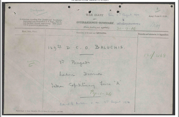
In the mean time I want to illustrate how you can look at a hand unit drawn map (Oct 1914) and transpose this to today using Google Maps and on site photographs.
From the war diaries I given the map below.

This map does not represent where Sepoy Khan’s VC action took place. That detail will follow soon.
Taking details from the War Diary hand drawn map and visiting the area I feel the Baluchis were based in the following location. You can see that I have marked the Indian Memorial in Hollebeke.


The red line is the 129th Baluchis positions. With the Canal showing at the top of the picture with the Blue line. The yellow box shows the area of the Chateau.

In the war diaries map, there is a second roadway indicated to Wijtschate, but I believe this was the Dam Strasse which has now been removed back to farmland. (Also, there is a debate if the Dam Strasse was a sunken road or raised road)
On the war diary map you can see a farmhouse coloured in Brown. I understand this was captured by the Germans at this time and had to be retaken. I feel this may be Stal ‘t Eekhof.


Picture of the road through the golf course in the direction of the Canal. The Chateau would have been set back on the right hand side.

Picture taken of the field left of the road with the farm house Stal ‘t Eekhof. behind me and where the Baluchis were positioned. At the end of the road is the start of the road shown above through the golf course.

Picture in the opposite direction from the road between the golf course. The field in front would have had the Dam Strasse going through it as shown on the hand drawn map. (Now returned to fam land).

This could be the farm house which was captured by the Germans around the end of October 1914.

Picture of the golf course holes to the left of the dividing road. This would also have been Baluchis positions.

Overall I wanted to show how you can take a hand drawn military map, found within the war diaries and by using Google Maps and being on the ground you can replicate the positions and understand the change in terrain.
I will return to the positions of the 129th Baluchis and Sepoy Khan when I have finished my research in the next week or so.
Callum, wonderful you have been asked to be the ambassador for the Friends of the Indian Memorial. You’ve done a great job in explaining the maps. I did not know there were Chinese soldiers in WWI. I thought they had all be brought as laborers. I’ll have to read up about it! Thanks for the information.
Awesome stuff!